Monday, December 26, 2016

Hike #29 - Boxley Valley

We have not hiked since completing our 100 mile goal.  Without the goal still lingering, we did not have the same pressing need to get outdoors. This just verifies why this goal has been so good for us and why we will set more goals in the future.  60+ degree weather on Christmas break is all the excuse needed to get out there again.

The Buffalo River Trail is one of the famous through trails in Arkansas, although there is some debate about where it starts and stops. Mom and dad had done a section of the trail near Steel Creek, but we had not done it as a family.  This trail has the most spectacular view of any trail we have done, so it was definitely worth the time to do it again.  Steel Creek is an amazing tent only campsite.  If you want to get a site for the weekend during nice weather, you need to arrive on Thursday morning and hope to get lucky.  If it is floating season, get there on Wednesday.  This time of year the water is shut off and the campground was empty. 

From Steel Creek, we did the section that heads east towards Kyle's Landing.  The best view comes 1.5 miles in, so we set that as our goal.  The trail is pretty the entire way with lots of ups and downs, rock formations, and a creek crossing (i.e. Steel Creek).  With the dead colors of winter, the green ferns and mosses really jumped out.  The pièce de résistance:


We hiked back down and had a picnic lunch at the campground and splashed in the river, which is right at the base of the bluffs you see above.  It was great to just sit by the river and let the kids interact with nature without any adult intervention.  They threw rocks, built a dam, found a cave, and got wet. 

Less than 10 minutes from here is Lost Valley, which we have done many times.  It is one of our favorite spots in the state, so we don't really get tired of it. The highlight of the day is that it was the first day our four year old walked the entire day, which was a total of over 7 miles!

Travel time from home: 1 hour, 15 minutes
Today's miles: 7.28
Remaining miles: -9.57

Saturday, November 5, 2016

Hike #28 - WE DID IT!!!

We have had lots of discussion about what we should do for our 100 mile hike. We decided that we spend so much time at church and school, that the chapel should be our final destination.  The kids have always wanted to walk or ride their bikes from home to school, and we thought this would be a fun culmination.  We had just under three miles remaining, and we gauged the whole hike to be a little more than five miles.  The kids made signs for a 100 mile photo op, and off we went.

WE DID IT!!!


It was a little different hiking on a street, and there was a much greater sense of danger.  Our pace was about one mile per hour faster than usual too.  I guess the rocks and bumps slow us down more than I expected.  This was also our first hike using a stroller.  

Everyone was very excited to finish, and we celebrated with a special dinner out tonight.  The only thing left is to see where we finish the year. 


Travel time from home: 0 minutes
Today's miles: 5.25
Remaining miles: -2.29!!!!!!!!!

Sunday, October 30, 2016

Hike #27 - Buffalo Overlook Trail

This is the shortest hike we have done this year.  As we left our camp trip I talked about yesterday we didn't want to take a lot of time before getting on the road, but we did want to check out the Overlook Trail. The Overlook Trail uses the same parking lot as the Indian Rockhouse.  From the parking lot to the overlook and back is only three quarters of a mile for a great view.


If this isn't enough hiking for you, you have the option of connecting to the Campground Trail and either looping back to the parking lot or returning to the campground.

Travel time from home: 2.5 hours
Today's miles: .78 miles
Remaining miles: 2.96

Saturday, October 29, 2016

Hike #26 - Indian Rock House

Four years ago we camped at Buffalo Point and hiked the Indian Rockhouse trail. (Buffalo Point with my daughter walking in the water is the background image on this blog.)  Since then we have often said that it was our favorite campsite and favorite hike that we have done.  We have camped and hiked a whole lot more in the meantime, and recently I have wondered whether or not that opinion would still hold up.  Northwest Arkansas has spoiled us with so many great outdoor spots less than an hour away from home.  With Buffalo Point being two and half hours away, we haven't felt compelled to get back out there.

Some old friends got us motivated.  Before moving to NWA we lived in Little Rock which is also two and half hours from Buffalo Point.  From Little Rock that distance to a great campsite is more normal, so when we decided to meet some old Little Rock friends for a camp trip, Buffalo Point it was.   Let's start by saying our opinion of Indian Rockhouse as our favorite trail was confirmed.

The trailhead is located on highway 268 and is a three minute drive from the campground.  It is well marked and there is plenty of parking.  The wonders of this trail start soon.  Within three minutes of starting the hike, we saw two men come in from the side of the trail.  They said they had just been exploring a cave.  A short shimmy through a tight spot opened up into big caverns.  Since we had a lot of kids, who had already run ahead we didn't try to look into it, but apparently there are similar spots all along the trail.  In plain sight along the way are more caves, an abandoned zinc mine, a sink hole, and a small waterfall.  Even with no rain in recent memory, there was still a trickle.  The rock wall along the waterfall begs kids to climb on it, which they did.

A long stretch of the trail follows a creek bed which was dry today. As you come to the end of the creek there is a split with one side looping back to the trailhead and the other a spur to the Rockhouse.  This spur also has some great things to see including more caves and cascading pools that have created what is known as "Sculptured Bedrock."

The Indian Rockhouse is amazing.  It is huge!  It was once an enclosed cave and flowstone and stalactites are still visible. It takes zero imagination to see how it would make a perfect shelter for someone living in the woods.  It is so spacious that someone could build a fire a big as they wanted and have no ventilation troubles.  The main cavern could easily keep hundreds of people out of the weather.  A clear running stream flows constantly out of the rock on one side and back into the rock on the water to provide water.  Climbing the rocks across the creek, which we did, takes you into another back cavern that is less spacious, but still large enough to serve as several "rooms" for living, even a little niche that calls you to climb inside and take a nap.  It is just amazing.

The hike back to the car has some more great sights with flowing water and places known as "natural bathtubs."  However, the hike out is very strenuous.  Last time we hiked it, it was over 100 degrees.  Today it was 80, and still it took about all we had.  To give pregnant momma a break, our ten year old, donned the baby in the backpack for the first time.  He went from very excited to very tired, very quickly.

The trail itself is about 3.5 miles.  By the time we included our extra steps exploring the rockhouse, we were up to 6.6 miles!  This is definitely worth your trip to come see.


Travel time from home: 2.5 hours :(
Today's miles: 6.67
Remaining miles: 3.74


Saturday, October 22, 2016

Hike #25 - Ozark Highlands Trail

We have a couple of through hikes in our area.  We haven't attempted any yet, but one of the favorites is the Ozark Highlands Trail (OHT).  We occasionally head down the affectionately named Highway 23 Pigtrail, such as when we camped at Redding Recreation Area a few weeks ago.  One of the OHT trailheads is on Hwy 23.  We have wanted to do this part of the trail for a while, but have never made it.  Today we finally did.

This trailhead is called Cherry Bend.  Cherry Bend is around mile 36 (moving from south to north) on this 260+ mile trail.  From Cherry Bend you can go in either direction.  We headed south because I knew there was a short spur close to the trailhead that went what is known as Rockhouse.  Rockhouse is natural overhanging rock that at some time in the past someone closed in with rock walls.  We spent a few minutes checking it out.  It was a neat spot, but sadly there was quite a pile of beer cans
left behind.

From the outset, this trail started uphill.  It became clear pretty quickly that this wasn't going to stop anytime soon.  There are some great views along the way of the Ozarks, but this trail is very rugged and climbed steadily uphill for the first 1.75 miles.  This is not a beginner hike.  Along the way, we were accompanied by the steady drone of motorcycles on 23, because there must be some state law that says a motorcycle must travel on 23 approximately every 3.8 seconds.  We began to the see the top of a ridge and with it the hope of a downhill stretch.  There is an ATV trail that runs along this ridge that gets about as much traffic as 23.  This would probably be a good source of emergency help if it was ever needed on the trail.

We have been trying to get our three-year-old to do more walking on his own, and today he was a champ.  He did the whole uphill stretch.  He began to ask to be carried around 2.2 miles, and we finally did begin carrying him around 2.5.  He really did a great job, but between this and the uphill terrain, our standard pace of a 36 minute mile became a 56 minute mile!  This was pretty torturous, but the rest of the way went much faster.  We got back to the car with 3.96 miles completed.  That was unacceptable.  There was another unidentified trail that left the parking area, so we decided to get to 4.0 this way.  Very quickly this trail came to a cliff with a pretty trecherous rocky trail to go down and around it.  The kids were excited about this, but we decided we were at the end.  Back to the van it was.

Travel time from home: 35 minutes
Today's miles: 4.0
Remaining miles: 10.41

Monday, October 10, 2016

Stuff We Like - Child Carriers

So how do you lug a couple of 25-30 kids 100 miles through the woods?  There are a lot of child carriers out there.  We have three that we use, and all three have their uses.  One we heavily researched and bought new.  Two were given to us by friends whose kids had outgrown them, so we really can't say how they compare to other similar products.  They have worked fine for us though.

Ergo Baby
This is the one mom uses almost exclusively and dad only if someone neither of the others are in the car.

Pros:
Can be worn front or back
Works for infants
Handy head strap so babies' noggins down bounce if they fall asleep

Cons:
No barrier between your body and the baby's creates lots of shared sweat
Requires delicate maneuvering to put on without help


Kelty Kids Backcountry
This is the one dad uses almost exclusively.  As far as I can tell, this is no longer available except used on eBay or such sites.

Pros:
Very sturdy
Five-point harness and seat makes it easy to load for one person (baby stays secure while lifting)
Detachable day pack
Great adjustable straps
Carried a five year old once after a fall
Kelty has replaced all broken buckles at no charge (even considering we are not the original owners)

Cons:
A wide spread really pulls your center of gravity backwards
So sturdy it temps you to leave your child in it unattended.  Don't.


Tough Traveler Colt
This one comes in handy for dad, but mom never uses.  Dad keeps this one in the van for use at kids' sporting events, etc.  It makes a good backup when hiking with someone who has kids but doesn't have a carrier.

Pros:
Totally rad website!
Lightweight and compact
Handy pocket (always have a backup diaper)
Easy to load for one person

Cons:
The bar that cuts across the top of your back (no bueno)
Not the best straps


Sunday, October 2, 2016

Hike #24 - Hidden Diversity

We are really enjoying Hobbs State Park Conservation Area.  We have already done the Pigeon Roost trail and the Shaddox Hollow trail.  Today we got some hiking in, but what drew us here was the Fall Festival that they have on the first Sunday of October each year.

The fall festival follows the Historical Van Winkle trail.  This trail is only about a mile long and either paved or hard packed gravel the whole way.  It winds through the homestead of the Van Winkle family.  You can see the foundation ruins of several of their buildings including the blacksmith shop, mill, and spring house.  For the festival today the had tall tale tellers, animal furs, blacksmith demonstrations, apple cider making, dutch oven cooking (very good!), and pioneer games.  Without the festivities, this short trail has some small but pretty bluffs, a clear creek, and open spaces for running and playing.

Since this trail only got us a mile, we went from here to the 
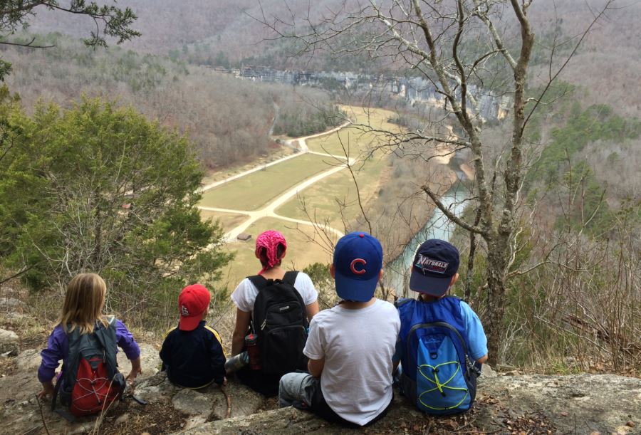
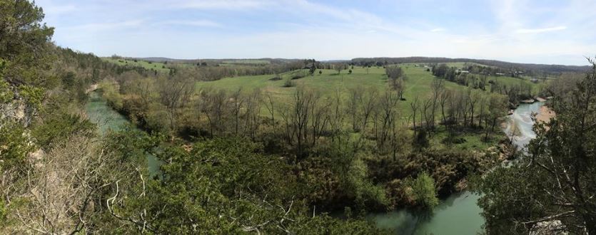
Hidden Diversity multi-use trail.  This trail is hike, bike, and horse friendly.  The trail is actually big enough that various sections are named separately.  We started from the Townsend Ridge trailhead (it is closest to where we were already) and did part of the War Eagle Valley trail.  This trail is a six mile loop.  We headed east at fork where the two sides of the loop come together.  This forest seems much more foresty than most of the other trails we have hiked on.  It's not that the trail is lightly used, because the path is very clear, but there seems to be a lot growing all around.  There are a lot ferns and mushrooms that to me feel more alive than just trees.  This is one of the best marked trails we have done with good signs at all the splits and white blazes at least every fifty feet. They are even appropriately slanted for trail turns, which I am snobby about.  It is a pretty strenuous trail with long steady climbs and long steady descents, but it is never very steep.  About a mile and half in there is an overlook with a bench, but there are three huge trees that block most of the view.  It would be much nicer in leaf-off which is coming soon.  At the two mile point we came to a view of the War Eagle Creek.  There are two benches here and a sign warning you of the sheer drop off to the creek probably forty feet below.  The dirt to the edge looks pretty loose too, so definitely be careful.  We told the kids they were required to sit on the benches, and that I would take them closer to the edge for a picture.  However, at this point things got interesting.

As we were sitting having a snack, our one-year-old grabbed a bug that was crawling on his arm,
tried to eat it, and then started screaming.  I swatted the black and yellow bug out of his mouth but was afraid it might have stung him.  Instead of pictures at the prettiest spot on the trail, we picked up and headed back to the van. About half a mile back, my daughter told me that the baby's mouth was crooked.  The picture speaks for itself.  We have a child with severe food allergies, so we always bring an EpiPen with us.  For some reason we did not have it with us, so if his swelling continued we were two miles away from the medicine he needed.  On top of this, because we have the food allergy we have prepped our big kids that face swelling is potentially life-threatening, so at this point they began to get a bit hysterical.  Good times!  We continued hiking out, the swelling never got bigger than this, and everyone lives to see another day.  Another first in the family hiking adventures.

We will definitely be back for more Hidden Diversity.

Travel time from home: 45 minutes
Today's miles: 4.94
Remaining miles: 14.41

Monday, September 26, 2016

Sunday, September 18, 2016

Hike #23 - Redding Loop

This weekend we aimed big, but wisely came up a bit short.  We went camping this weekend with my brother.  We had plans to camp at Redding Recreation Area Friday and Saturday, but thunderstorms Friday night delayed us.  The weather was perfect though on Saturday morning.  Redding Loop takes off directly from the campground.  The loop is somewhere around 6 miles, with a spur to Spy Rock that makes it around 8.  Our goal was to do the whole thing, including Spy Rock.  We figured that we had done almost 8 miles once before, so if we pushed ourselves, we could make it.

From the campground the trail is a level path through pine trees.  Pine needles make a nice cushioned walking surface.  However, this particular leg of the trail seems to be rarely used, and the trail was almost nonexistent in some places.  We eventually crossed highway 215, and there was a parking area for the trail by the road.  Once the trail crossed the highway the trail was much easier to see.  But, it got much steeper.

We did not bring a map of the trail with us, but we were able to get one pulled up on a smartphone with intermittent service.  One thing that we have found helpful is to compare the map to our GPS tracker.  Because our progress line on the GPS matches the trail map exactly, it makes it very easy to tell where you are.

We started hiking around 9 a.m., and soon the kids were hungry.  The pace was slow and the cooperation level was low.  We bargained with them that we would eat at the two mile mark.  Once they had some food, their spirits were much better.  Right after this two mile mark the trail leveled back off and we had the best scenery of the trail.  However, we began to realize that every step we took was another step back to camp.  At the three mile point we knew we had to make a decision. Either keep going forward and try to complete the eight miles, or turn around and be happy with six.  In order to enjoy the rest of the camp trip, we decided to turn around.  Things went much quicker down hill, and we even saw a waterfall spot we had missed on the way up.  (It hasn't rained much lately, so it was only a trickle.)  When we crossed 215 again and realized we still had another mile to go, we were happy we had turned back.  Everyone was very ready to be back at camp during that last mile, although no one more so than the baby who cried from here on.  We had turned around just past the point of everyone wanting to be finished, but not past the point of being miserable.  As I am writing this, the best trail map I can find for this trail, says that the loop plus Spy Rock would have been 10.0 miles exactly.  I am ever more glad we turned back than I was then!

One plus about this trail map I just looked up though is that it had this awesome 3D map that makes this trail look very epic!


Our campground is marked as RS-01 in this image.  We went right at the split at RS-02, and we made it to RS.07 before turning around.  We'll have to save Spy Rock for another day. 

Travel time from home: 1 hour
Today's miles: 6.00
Remaining miles: 19.35!

Thursday, September 15, 2016

We should have known better

Pretty sure we have poison ivy.  From Lake Wilson.  Again.

We still had some refills on the prescription from April, so we'll give that a shot.

(Update: Nope.  Two back-to-back doses of prednisone and the poison ivy is worse not better. To the doctor we a-go.)

Sunday, September 11, 2016

Hike #22 - Lake Wilson (Part 2)

Whenever we want to add a few miles to our total, but don't have a lot of time, Lake Wilson is our go to spot. As we learned last time we were here, this is an easy but pretty 2.5 miles just down the road.  Again we were surprised at how many people were out using this lake that we had previously thought unknown.  There's not much to add from last time we came.  The first half mile takes you from the parking area on the west side of the lake to the loop on the east side of the lake.  Where the spur meets the loop there is a dry creek bed.  I assume it is flowing after hard rains to feed the lake, but we have only seen it dry.  Today, instead of following the trail, we hiked about a quarter mile up the creek bed and then did a 10 yard bush whack back to the trail.

Other than that the only thin we did differently is make the little guy walk a little more.  He still generally prefers to ride in the backpack, but we need to push him to hike a little more as we approach a fourth birthday.  He did about a mile and half on his own feet, and he enjoyed the big rocks.

Travel time from home: 15 minutes
Today's miles: 2.77
Remaining miles: 25.35

Sunday, August 14, 2016

Hike #21 - Lake Sequoyah (Part 2)

You can't beat a five minute drive to the trail when you need to add some miles or kill some time on an afternoon.  This is especially true when it is the last week of summer!  Because it is so close to home, we have come to Lake Sequoyah several times.  Last time we were here I pointed out the improvements to the area such as new trail signs that indicated trails we did not know existed.  Today we decided to give these a try.  What an adventure!

We have hiked both of the trails on the east side of the lake.  Today we wanted to try the west side.  There is a simply out and back trail that follows the shore and includes a fishing pier out into the water.  Back by the parking area trails just meander through some nice trees.  I expect these are mostly made for and by horses.  There is a ranch next to the lake and we passed  groups on horses several times throughout the day.


Now we decided to get adventurous and try the Island Trail.  The map points out that this requires a water crossing.  The White River feeds the lake on one side, and on the other the spillway joins the West Fork of the White River to continue on as the While River.  This is what we had to cross.  It wasn't much more than knee deep on an adult, but slippery rocks and 30 pound kids on your back make it seem more treacherous.


The signs said the Island Trail is marked with blue blazes, but we had a hard time finding either a trail or blazes.  We knew we wanted to see the spillway, so we headed that direction.  We got in some legitimate bush whacking.  Not only did we make it to the spillway, but we also occasionally saw some blue blazes.  We still did not see the trail that these blazes supposedly marked, so the bush whacking continued.  Finally we saw what resembled a trail, and we were able to resume the meandering through nice trees on horse paths.  We again made our way to parts of the river that were less than knee deep and nice for wading across.  We also came to a spot where, thanks to our Runtastic app and Google maps, we were able to see how we could connect back to the earlier trail without a water crossing.  We finally decided that the reason there was no visible trail is that high water at some point had covered the trail with brush and debris.


In the end, we were glad that it had because we felt a renewed sense of wilderness cred after this adventure!  We continue to be amazed that such a beautiful place is right on our doorstep.

Travel time from home: 10 minutes
Today's miles: A hard earned 2.61
Remaining miles: 28.12


Saturday, July 23, 2016

Hike #20 - Shaddox Hollow

Today we made our second trip to Hobbs State Park. (Actually after our first Pigeon Roost excursion, mom and dad came back for a backpacking trip sans kiddos, but since that wasn't the whole family, it doesn't make this blog.) Some friends invited us to stay at their house on Beaver Lake for the weekend, and they led us on their favorite Hobbs Trail, Shaddox Hollow.

Shaddox Hollow is a fairly simple 1.75 mile loop.  We took the left fork out of the parking lot.  Just about one mile in we passed a short but steep spur trail that turned out to be the highlight of the trip.  We could see from the main trail that the steep climb to our left led to some exposed rock, but we couldn't tell much about it.  After we scrambled up, we saw a bunch of rocks just made for kids to climb on and a nice overhang with a perfect tunnel cave.  The tunnel is almost a perfect circle about three feet tall and probably twenty feet in.  After that it gets smaller and curves, but we still couldn't see the end.  If someone was brave enough to shimmy in on their belly (we were not), it could go on for quite a while.

The rest of the trail is not terribly unique, but it is very pretty all the way.  This is a very good family hike that can be done in less than an hour even with the extra exploring.

(Big kids like to run ahead and try to beat you back to the car.)
Travel time from home: 45 minutes
Today's miles: 1.84
Remaining miles: 30.73

Thursday, July 21, 2016

Hike #19 - Devil's Den (Part 3)

You just can't get enough of Devil's Den.  We started our year of hiking there, and we were back in May.  Today we had some family in town from the DC area, and we met them here for a hike.  There isn't a much better place to meet someone.

We were at least able to throw in a trail we hadn't done before (at least not this year!), the Yellow Rock trail.  Yellow Rock is a 3.5 mile loop trail with two trailheads, each with good parking.  We started from the bridge across Lee Creek, and from this side you get a brief glimpse of the aptly named Yellow Rock. The Yellow Rock is a cliff outcropping that juts out from the rest of the forest.  The sheer drop into the creek valley creates some fantastic views best observed from your belly. You definitely don't want the kids too far away from you here.  It is yet another remarkable spot in this park.  Even before the eponymous rock, there are some remarkable rock formations with several small caves weaving in and out.  There are plenty of places to enjoy being off trail. 

We took a quick dip in Lee Creek with the cousins, and then put in another 2.5 miles on the Devil's Den trail which we have now done a few times. 

Travel time from home: 35 minutes
Today's miles: 5.97
Remaining miles: 32.57


Sunday, July 10, 2016

Hike #18 - Tanyard Creek

This is a new favorite spot that we will definitely be back to.  Tanyard Creek Nature Trail winds through woods, neighborhoods, and golf courses in Bella Vista, Arkansas.  Although the place was packed with people all day, there was plenty of water to go around, and we found a nice quite bend to splash around in for hours.

There is a big parking lot with a pavilion and picnic tables, but you are missing out if you hang around there for long.  A paved trail leads away from the parking lot, which greatly concerned our kids who thought this would be another "walk" instead of a hike.

Whether you quickly get off the paved trail into the woods or follow it until it ends, you quickly find water.  Unpaved trails meander across, through, and on either side of the crystal clear water.  However, we did most of our walking in the creek itself.  There is at least one neat cave that you wander into a short way with water flowing through it.

We finally just picked a spot and sat and splashed for an hour or more.  There are more neat spots here than we could check out in one day, including a cable bridge with a warning to be occupied by no more than eight people at once.  One that we did get to see was the waterfall that comes from the Windsor Lake Dam, and it is impressive.  We will definitely be back.


Another highlight of the day is that our three-year-old did the whole 3.75 miles on his own two feet today.  That is a first.  Although it is exciting, it has the potential to drastically slow our pace in the coming months.

Travel time from home: 50 minutes
Today's miles: 3.75
Remaining miles: 38.54

Thursday, June 30, 2016

Hike #17 - Point Washington State Forest, Florida

Other than visiting grandma and grandpa, our family has not taken a family vacation in ten years.  We had one kid then. This summer we loaded up and headed to Grayton Beach State Park in the Destin, Florida area.

We have stayed in Grayton before, and we came back for several reasons.  First, the state park has cabins that are significantly cheaper than most of the rentals in the area. Second, the state park has a private beach with very few people and rangers who monitor the water for riptides and dangerous marine life (sharks, jellyfish, sea lice, oh my!).  We spent most days in the water, but we couldn't let the whole trip go by without at least one hike.  The trail was technically Point Washington State Forest, but it seemed that it ran together with some of the Grayton trails.  In the future though, we might pass on hiking in Florida.

Reasons we prefer Arkansas hiking to Florida hiking:

  1. Wildlife - The sign at the trailhead warns hikers of rattlesnakes, water moccasins, and coral snakes.  The only one we don't have in Arkansas is coral snakes, and we replace them with copperheads.  However, in our previous 50+ miles in Arkansas this year, we have see a total of zero snakes. On this trail we saw two, and they were big, and they were right on the edge of the trail.  It put us all on edge for the entire time.  This doesn't even consider the "watch out for gators" sign by the lake we passed.
  2. Terrain - This trail is flat!  There was zero elevation change, and zero rocks to see or climb.  The trail was sand, sand, and more sand.  Everyone can tolerate sand at the beach, but once you leave the beach it is just a nuisance that you can't wait to get rid of.
  3. Heat - For some reason people expect Florida to be hot, but the temperatures there are no hotter than the temperatures at home.  And don't say "it's not the heat, it's the humidity," because Arkansas has crazy humidity too.  However, the heat was brutal on this trail.  We came up with two factors.  First, in Arkansas you are usually hiking in the woods with a nice canopy of hardwood trees above.  Here you have scrawny pine trees if you have anything.  Second, below the Arkansas canopy you have leaf strewn brown dirt.  Here you have the white sand reflecting as much sunlight up at you from the ground as you have the sun beating down on you from above. Let's just say, the ocean felt particularly nice when we got back.  
(Don't worry, the mohawk went away as soon as we left the beach.)
Our family unanimously agrees that hiking in Arkansas is better.  Not that we doubted it before.

Travel time from home: 12 hours, 20 minutes (plus 3 hours worth of bathroom breaks)
Today's miles: 4.56
Remaining miles: 42.29

Saturday, June 18, 2016

Hike #16 - Mt. Kessler (Part 2)

As the boys' Cub Scout pack has gotten more active, they have started to put a lot of hikes on the schedule.  Families are always invited to these hikes, so we try to take advantage when we can.  Today the pack hit Mt. Kessler, which we have already done once this year.  You can never get tired of Rock City.


The highlight for us today was that we crossed the 50 mile threshold!  We hit it exactly at the best view on the trail. 50 miles before the halfway point of the year puts us ahead of pace. On we go!


Travel time from home: 15 minutes
Today's miles: 4.42
Remaining miles: 46.85

Saturday, June 11, 2016

Hike #15 - Lake Wedington

If we ever want to take a quick camp trip that is nice but not far away, we head to Lake Wedington. We just wrapped up one such trip with some friends.  Even though we had camped here before, we had never done the Lake Wedington trail.  We were there for the camping, and we did the hike just to add some miles without much thought for the trail.  The trail turned out to be spectacular.  

Although the trailhead is only about a quarter mile from the camp ground, the road to get there is windy and cars move quickly, we drove to the trailhead.  Earlier in the day we had used the swimming area and it was the typical muddy water that you find at any day use swimming area.  Along the trail though the water was crystal clear.  You could easily see eight inch fish swimming just by the shore.  Of the 1.83 miles we hiked, at least 1.5 of them were right on the water, which was beautiful as the sun set.  We knew there was a waterfall on the trail, but we weren't expecting much.  The trail isn't very well marked and some places look like makeshift offshoots of the main trail, so we weren't even sure we would find the waterfall.  Once we did though, we were very impressed.  The waterfall is part of the spillway from the lake, so I guess it is technically man-made, but we have noticed that kids don't really care about that kind of stuff.  

The kids of course were not satisfied just looking at it from the bottom, so we had to try to get to the top.  This added another level to the adventure.  At the top of the waterfall there was a wide stone wall that channeled the lake water to the waterfall spillway.  We realized we could either turn around and backtrack the trail, or we could scale the wall and hike along he levy back to the trail.  It wasn't a very tough decision.  (Earlier we had seen that there was a trail across the levy and that it did connect to the main trail.)  

This is definitely a hike we would do again and recommend to others.  It would be great to see the waterfall after some big rains when the lake is up. 

Travel time from home: 45 minutes
Today's miles: 1.83
Remaining miles: 51.27

Sunday, May 15, 2016

Hike #14 - Artosphere

Today's hike had a very different flavor.  Our local Walton Arts Center is hosting a summer seriesArtosphere that seeks to combine local arts with nature.  Today we took advantage of "Trail Mix" along the Frisco Trail which runs right though Downtown Fayetteville.  We took a one and three quarter mile stroll along the paved Frisco Trail with frequent stops to enjoy local professional and amateur musicians ranging from bluegrass to classical.  There were also stations along the way for kids to create their own musical art.  Probably the highlight for the kids was the "bike zoo," which can be described best by this picture:


We ended our leisurely evening stroll in Wilson Park for some phenomenal acrobatic performers, Circa, music by Paula Fuga and the Okee Dokee Brothers, and more bike zoo. Quite a treat all around. 

Travel time from home: 15 minutes
Today's miles: 1.73
Miles remaining: 53.1

Saturday, May 14, 2016

Hike #13 - Lake Sequoyah

I'm not sure what the attachment to "Sequoyah" is here in Fayetteville, but today we hit another local spot, Lake Sequoyah.  We have found this spot is very well known among fishermen (and fisherwomen!), but the growth that encroaches on the trail (it is not so bad in fall/winter) makes it clear that it is little used among hikers.  We have done two different trails here, but we find that almost no one knows about it.  Someone seems to be trying to change that though.  There are some nice new signs with trail maps.  An exciting plus is that the trail maps include three more trails we didn't know about.  Two of them are only accessible during low water when you can cross the spillway.  Today we did the King Fisher Trail.

This out and back trail is just over 3 miles.  There are some nice views of the lake and some neat outcroppings and trail switchbacks.  The highlight for the kids though is a downed tree that was made for climbing.  The base is right by the trail, but the top branches prop it up so it stays level as the ground slopes away.  The result is that pretty quickly the kids are 12 feet off the ground.  They are much more excited about that than mom is.

There are some other neat features at the lake that are not exactly part of this trail.  You enter the park across an intimidating one-lane bridge.  One of the opposite side of the lake from this trail is a horse ranch where you can get trail rides around the lake.  There is also a very impressive spillway that ties into the white river.  Today the spillway had pretty high water.  A different day when we were here there was a family catching, cleaning, and cooking fish on a charcoal fire they had going by the spillway.


I also just came across this video of a segment of a local outdoor show that was made about Lake Sequoyah.


Travel time from home: 10 minutes
Today's miles 3.09
Remaining miles: 54.8

Monday, May 9, 2016

Stuff We Like - The Whistle System

Our kids, especially our boys, love to run ahead of us on the trail.  99% of the time we feel safe with them out of our site in the woods, but every so often we want to know where they are.  We tried to implement a whistle system, but our chintzy plastic whistles from the fish pond at the school carnival weren't cutting it.  So, we got these little beauties on Amazon:


The first time I blew it I thought it wasn't loud enough.  As I thought about it more though, I realized I don't want it so loud that anyone in the park can hear.  I don't want the sound to carry much farther than the maximum distance I want between me and the kids.

Here is our system.  I keep one attached to my pack, and they kids keep one attached to their pack.  One whistle is a check-in.  Either I or the kids can start and the other will respond with one whistle.  This is just to say everybody's fine.  If I blow two whistles, the kids know that they need to come back closer until they can see us again.  Three whistles, blown by anyone, is an emergency, which we define as dangerous wildlife or serious injury.

We tried it for the first time at Hobbs, and it worked great.

Sunday, May 8, 2016

Hike #12 - Pigeon Roost

One of the nearby state parks that we had not checked out at all is Hobbs State Park, which is actually a Conservation Management Area.  We weren't sure what that meant exactly until we looked it up after the trip.  I assumed that it was meant to protect some threatened species, but it seems to be more about lack of development/roads to preserve the natural environment.  I also learned when I added the link above that Hobbs is our largest state park at 12,000+ acres.  The real draw of Hobbs is that it has 22 miles of lakefront.


We were also pleasantly surprised to find that Hobbs has the best visitors center that we have seen yet at a state park.  It has a cave simulation that was realistic enough for us to wonder if it was a real cave rather than a simulation.  It also had a large 3D map showing all of the trails and features of the park, and they would light up when you pushed the appropriate button.  There were several ladies working in there who were very excited to help.  They suggested several trails for us, but when they saw all of the kids they started suggesting half mile hikes.  We found their lack of faith disturbing.  We decided on the 4.5 mile Pigeon Roost loop.  There is actually a second loop off of the main loop that makes it 8.5 miles.  There are five first-come-first-serve backpacking sites on this loop, but we will save that for another time.  There is a lot more to see there than we had time for because they lock the gates of the visitor center parking lot at 5:00.  If your hike will take you past that time, like ours did, be sure you don't park there.

Pigeon Roost is a very pretty trail.  It is not overly strenuous, but it has some nice ups and downs, so you do get a workout.  About a mile in you get your one view of Beaver Lake.  Our kids can never quite comprehend that it is the water we drink.  There isn't much else of note on the trail other than standard Arkansas nature, which is never bad.

We had a great unexpected learning moment for this kids as we got towards the end of the trail.  Our
five-year-old spotted a pretty butterfly on the ground.  We quickly realized it was injured.  He was very concerned about this and began asking questions about how he could help it.  It was heartbreaking to tell him that he couldn't help it, but they all understood very well.  Since we couldn't help it survive, we settled on surrounding it with wildflowers to give it a peaceful death.

We will definitely have to head back to Hobbs to check out more trails.

Travel time from home: 45 minutes
Today's miles: 4.4
Remaining miles: 57.89

Monday, May 2, 2016

Hike #11 - Devil's Den (Part 2)

Today we returned to our first adventure of the year, Devil's Den,  We had family in town, and were joined by a grandma, grandpa, and uncle.  Grandma and grandpa did not complete the whole trail, but it was great to have them there.  The water was flowing nicely on the waterfalls today.  Since we've already explored this trail this year, there aren't many new details to share.

The most unique thing was an up-close encounter with a Pileated Woodpecker.  He was huge, and he was low on the trunk, only about four feet from the ground.  He didn't like people too much, but he didn't fly away when we got
close.  He would just bounce around the other side of the tree and then back again as we walked off.  It was something we had never seen before.


Travel time from home: 35 minutes
Today's miles: 2.66
Remaining miles: 62.29

Wednesday, April 27, 2016

It Was Bound To Happen

Among the wonderful flora and fauna we encountered at Lake Wilson was everyone's favorite: poison ivy.  Thankfully we have a great GP who gives us enough prescription refills to cover its inevitable passing through all of the kids.  Poor kid got it bad!

Leaves of three, let them be!


Saturday, April 23, 2016

Hike #10 - Clark Trail at Lake Wilson

I had noticed Lake Wilson on a map of the city months ago and had wondered if there was anything there to explore.  Just this morning some friends tipped us off to the trail there, and because this 2.5 mile loop is so close to home we thought we would try something different.  We finished dinner, left the dishes on the table, and did our first sunset hike.  The late April evening weather was perfect for a windows down drive.

Lake Wilson was the original water supply for the city of Fayetteville, but has now been replaced by Beaver Lake.  Joe and Maxine Clark were conservation minded citizens who helped support the growth of the local trail system.  This is a great trail, and we cannot believe we did not even know it existed.

The lake is very pretty, and we were surprised at the number of other people out there on a Saturday evening hiking, fishing from boats and the shore, and swimming (against the rules, which we would never approve ;) ).  There is a nice pavilion with picnic tables at the trailhead.  This is one of the best marked trails that we have done yet. The three year old is obsessed with loudly pointing out every tree blaze, and he was not disappointed here.  There are some great rocks here that are begging us to come back when we have more time to explore.  One of the things I love about loop trails is that if you hike the opposite direction next time it is like exploring a whole new trail.  The last 3/4 mile was right along the bank as dusk was coming on, and it was perfect.  Another feather in the cap of Fayetteville.

One thing that may alter our hiking in the coming months is that the three-year-old is growing restless in the backpack.  Today his short little legs walked the first and last half mile.

Travel time from home: 15 minutes
Today's miles: 2.66
Remaining miles: 64.95

Saturday, April 16, 2016

Hike #9 - Cub Scout Camp Out

We have done Cub Scouts for the past three years, and this year we have a pack that is very organized and active.  We have gotten very busy lately, and we have been considering cutting some activities from our schedule for the coming year.  Cub Scouts is one of the activities that will make the cut.

This weekend the pack did its first camp out of the year.  The pack had certain camping requirements they had to check off their list.  Hiking was not one of the major items, so we only got in 2/3 mile on an unnamed trail at Horseshoe Bend on Beaver Lake.

One unexpected plus: We love a good hole-in-the-wall restaurant.  On the way we passed Monte Ne Chicken which caught our eye.  When we got to the camp out, several people were talking about it and how good it was.  We have to make a special trip up there to eat sometime.


Travel time from home: 50 minutes
Today's miles: 0.68
Remaining miles: 67.61

Saturday, April 9, 2016

Hike #8 - Withrow Springs (Part 2)

We are enough miles into our goal that the time has come to start doubling up on trails.  We had our first trip to Withrow Springs in January.  Like most parks though, it has more than one trail.  We went here today for the Dogwood Trail because we are in the last days of the dogwood bloom.  This was a pretty little trail, and by little we mean 2/3 of a mile.  As we came around the last turn and saw the van, we realized our kids had turned a corner in their hiking.  We had completed the trail in only twenty minutes, and the unanimous response from the kids was "That's all!"  We are proud to say that according to our kids any hike under three miles almost isn't worth their time.


So, we headed back to the War Eagle trail that we had done in January.  April though is a much better time for enjoying the swimming hole.  One of the nice things about four boys, is that swimming can be enjoyed even if you forget to bring suits.


Travel time from home: 35 minutes
Today's miles: 2.08
Remaining miles: 68.29